

DAR – Dingle Adventure Race
June 8, 2024

DINGLE ADVENTURE RACE COURSE INFO
Course Details:
DAR Mini: 21.5Km
DAR Sport: 43Km
DAR Full: 75Km
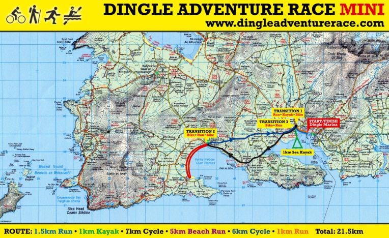
MINI 21.5km COURSE INFO
New to Adventure Racing and multi sport events, then give it a go with the DAR mini, this will give you a taste of running, biking, kayaking and the atmosphere that is invloved at these great events. You don’t have to be very fit for the mini, just willing to give it a go. Course for the mini is; 8km cyle from Dingle to Ventry beach, Run Ventry beach 5km, Cycle back to Dingle 6km, 0.7 run to kayak, 1km kayak and 1km Run to Finish. Total 21km
ROUTE DESCRIPTION
1. Cycle 8km Dingle to Ventry Distance 8km / 5 mls Height Gain 80m Height Loss 80m
2. Beach Run. Ventry Beach. Distance 5km / 3.2mls Height Gain 0m Height Loss 0m
All of the Run is on the beach with a few stream crossings
Kayak. Milltown. Distance 1km / 0.7 mls Height Loss or Gain 0 & 400m run to bike transition
3. Cycle: Ventry to Dingle via back road. Distance 6km / 4 mls Height Gain 80m Height Loss 80m
All of cycle is on surfaced roads.
5. Rack bike at transition Milltown, run 700m to kayak, kayak 1km.
6. Run 1km to Finish. e Dingle. Distance 1km / 0.7mls Height Gain 0m Height Loss 10m
DAR Sport Total Distance 21km / 13 mls Height Gain 160m / 500ft Height Loss 160m / 500ft
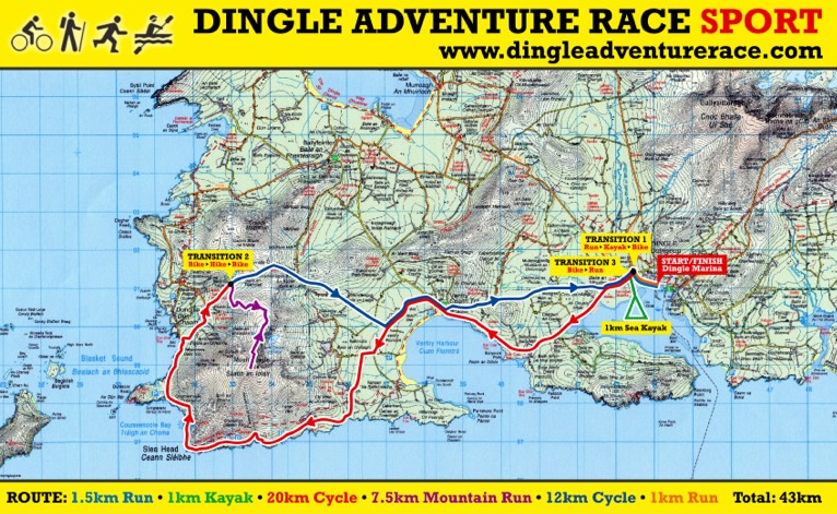
SPORT 43KM COURSE INFO
DAR Sport takes a spectacular route around the western point of the Dingle Peninsula and Ireland. DAR Sport, 08.30 Start; Total Distance 43km with 800m total ascent. Competitors will start on their bikes at Dingle Marina. It will be a rolling start for the first 1km cycle before cycling (21km) around Slea Head> hike or run (7.5km) Mt Eagle and cycle (11.5km) back to Dingle via Ventry, rack bikes at transition at Milltown before (0.7km) run to kayak. Kayak 1km in double sit-on-tops before final run 1km to Finish line in Dingle Marina.
ROUTE DESCRIPTION
1. Cycle: Dingle to Mt Eagle via Slea head. Distance 21km / 13 mls Height Gain 310m Height Loss 140m
2. Hike / Mountain Run. Mt Eagle. Distance 7.5km / 4.5mls Height Gain 390m Height Loss 390m
All of Mountain Hike Run is on rough trails.
3. Cycle: Mt Eagle to Dingle via Ventry. Distance 11.5km / 7 mls Height Gain 100m Height Loss 270m
All of cycle is on surfaced roads.
4. Run to Kayak. Rack bike at transition at Milltown, Run .7km to kayak and kayak 1km. Distance 1.7km / 1 mls Height Loss or Gain 0
5 Run 1km to finish at Dingle Marina. Distance 1km / 0.6 mls Height Loss or Gain 0
DAR Sport Total Distance 43km / 27 mls Height Gain 800m / 2,640ft Height Loss 800m / 2,640ft
FULL INFO
DAR: 11th year for DAR, The 45 mile/ 73km course will take you to some of the best gems on the Dingle peninsula, Co. Kerry, Ireland. Biking around Slea head, following in the footsteps of St Brandon climbing Ireland’s second highest Mountain range Mt Brandon and kayaking in Dingle Harbour.
ROUTE DESCRIPTION
1. Run 1km to the kayaks, kayak 1km on double sit on tops kayak, run 700m to bike transition (T1) Distance 2.7km / 1.6 mls Height Gain 10m Height Loss 0m
2. Cycle 43km around the Slea head drive to the Bike transiton (T2) at the foot of Mt Brandon at Baile Breac. Distance 43km / 27mls Height Gain 300m Height Loss 260m
All of cycle is on surfaced public roads.
3. Mt Brandon Run/Hike, this is a super 15.5km loop around Irelands second highest mountain range. 5km Hike will get you to the summit of Mt Brandon before a super ridge to get you on the Dingle way walking trail. (first 5km will see alot of competitors hike this before running the next 10.5km section which is very runable)
All of Mountain Hike Run is on rough mountain paths/trails.
4. Cycle 9km / 6mls from Baile Breac Trasntion (T2) to bike Transition (T1/3) at Milltown/Dingle. Distance 9km / 6 mls Height Gain 60m Loss 100 & Rack bike before final 1 km run to finish line at Dingle marina.
Total Distance 73km / 45.5 mls Height Gain 1490m / 4,910ft Height Loss 1490m / 4,910f
