2024-07-25T00:00:00+01:00
Quest – Kenmare
March 2, 2019
|
Sold Out
***SOLD OUT***Please note there has been a change to the Expert Course.
With 3 challenging routes to test you no matter what level of fitness you have. Run, cycle and kayak across the Kenmare Bay, Gleninchiquinn, The Beara Peninsula, Caha Pass and Kenmare town.
Choose from one of the following routes:
- 28K Challenge
- 43K Sport
- 79k Expert
28KM CHALLENGE ROUTE INFORMATION
All routes are subject to final permissions from statutory bodies and are subject to change
The race consists of the following 6 stages:
Stage 1
Starting in Kenmare town on your bike with a controlled rolling start for 1km you will cycle past Sheen Falls and through the historical Bonane Valley. This is a secondary tarred road with grass in the middle of the road for most parts. A couple of gradual inclines until you arrive at the first transition at Bonane Heritage Park.
Terrain: Secondary roads, sealed tarmac.
Precautions: Open secondary roads, grass in the middle of the road, debris and water on road in parts.
Distance: 10.70km Cycle
Total Elevation: 321m
Route map for Quest Kenmare Challenge Route: Stage 1 Cycle 10K by Ollie Kirwan on plotaroute.com
Stage 2
From the transition at Bonane Heritage Park you will follow a trail on around Bonane Heritage park on gravel track with some steep sections. You will do 2 laps of this course.
Terrain: Trail, gravel track.
Precautions: Wet, loose debris, slippy under foot.
Distance: 4km Run
Total Elevation: 148m
Route map for Quest Kenmare Challenge Route: Stage 2 Run 4K by Ollie Kirwan on plotaroute.com
Stage 3
From the transition at Bonane Heritage Park you will follow the main road back to Kenmare with some fast downhill sections. Bike transition is on the pier/peninsula area in Kenmare Town.
Terrain: Sealed tarmac.
Precautions: Open roads to traffic.
Distance: 10.50km Cycle
Total descent: 121
Route map for Quest Kenmare Challenge Route: Stage 3 Cycle 10K by Ollie Kirwan on plotaroute.com
Stage 4
Bike transition is on the pier/peninsula area in Kenmare Town you will run to the kayak area to begin the kayak stage.
Distance: 1km Run
Stage 5
Kayaking on Kenmare Bay on double sit-on-top Kayaks. Final route of kayak to be confirmed closer to event day based on tidal conditions.
Distance: 1km Kayak
Stage 6
Final run to the finish line. From the kayak area there is a short run through town to the finish line in the Square in Kenmare where hot soup and a medal will be waiting for you.
Distance: 1.5km Run
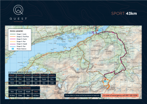
43KM SPORT ROUTE INFORMATION
All routes are subject to final permissions from statutory bodies and are subject to change
The race consists of the following 6 stages:

Stage 1
Starting in Kenmare town on your bike with a controlled rolling start for 1km you will cycle past Sheen Falls and through the historical Bonane Valley. This is a secondary tarred road with grass in the middle of the road for most parts. A couple of gradual inclines until you go back onto the main N71 Kenmare to Glengarriff Road. You will then cycle up to the transition at Molly Gallivans.
Terrain: Secondary roads, sealed tarmac.
Precautions: Open secondary roads, grass in the middle of the road, debris and water on the road in parts.
Distance: 18km Cycle
Total Elevation: 321m
Route map for Quest Kenmare Sport Route: Stage 1 Cycle 18K by Ollie Kirwan on plotaroute.com
Stage 2
From the Transition at Molly Gallivans you will follow a trail on road and track to the base of Esk Mountain. It is an up and back route to the top of Esk Mountain at an elevation of 370m to the Cork and Kerry border. Please note that elements of this route are affected by the weather and this could change the route slightly closer to the time of the event.
Terrain: Trail, gravel track, open mountain.
Precautions: Wet, loose debris, boggy underfoot.
Distance: 8km Run
Total Elevation: 370
Route map for Quest Kenmare Sport Route: Stage 2 Run 8K by Ollie Kirwan on plotaroute.com
Stage 3
From the transition at Molly Gallivans you will follow the main road back to Kenmare town. This is a fast downhill section with a good road surface. Bike transition is on the pier/peninsula area in Kenmare Town.
Terrain: Sealed tarmac.
Precautions: Roads open to traffic.
Distance: 14km Cycle
Total descent: 219
Route map for Quest Kenmare Sport Route: Stage 3 Cycle 14K by Ollie Kirwan on plotaroute.com
Stage 4
Bike transition is on the pier/peninsula area in Kenmare Town you will run to the kayak area to begin the kayak stage.
Distance: 1km Run
Stage 5
Kayaking on Kenmare Bay on double sit-on-top kayaks. Final route of kayak to be confirmed closer to event day based on tidal conditions.
Distance: 1K Kayak
Stage 6
Final run to the finish line. From the kayak area there is a short run through town to the finish line in the Square in Kenmare where hot soup and your medal will be waiting for you.
Distance: 1.5km Run
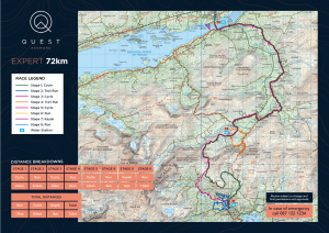
79K EXPERT ROUTE INFORMATION
All routes are subject to final permissions from statutory bodies and are subject to change
The race consists of the following 8 stages:

Stage 1
Starting in Kenmare town on your bike with a controlled rolling start for 1km you head out the N70 Ring of Kerry road, a fast flat 6km out to Templenoe. Turn left up Rossacoosane for a 7km climb up to Barrfinnihy Lake and Molls Gap. A fast decent from Molls Gap back towards Kenmare and a left turn to the bike transition at the bottom of the Kerry Way trail.
Terrain: Secondary roads, sealed tarmac.
Precautions: Open secondary roads, grass in the middle of the road, debris and water on road in parts..
Distance: 25km Cycle
Total Elevation: 466m
Route map for Quest Kenmare Expert Route: New Stage 1 Cycle 25K by Ollie Kirwan
Stage 2
Parking your bike in at the bike racking at the bottom of the Kerry Way trail (Transition 1) you will follow the famous Kerry Way trail. It is muddy and there are a few rivers/streams to jump over. It is 4km out and 4km back with amazing views across Killarney National Park.
Terrain: Well-maintained mountain trails.
Precautions: Slippery, wet stone across streams, timber sleepers and boggy.
Distance: 7.50km Trail Run
Total Elevation: 285m
Route map for Quest Kenmare New Expert Route: Stage 2 Run 7.5Km by Ollie Kirwan
Stage 3
Jump on the bike at Transition 1 and cycle through fast, downhill back roads to the Kilgarvan Road and cross over Roughty Bridge towards Bonane Valley. There is grass in the middle of the road and some short steep hills. Following the original stage 1 route cycle route to transition 2 at Molly Gallivans.
Terrain: Secondary roads, sealed tarmac.
Precautions: Open secondary roads, grass in the middle of the road and debris on road.
Distance: 21km Cycle
Total Elevation: 324m
Route map for Quest Kenmare New Expert Route: Stage 3 Cycle 21Km by Ollie Kirwan on plotaroute.com
Stage 4
From the transition at Molly Gallivans you will follow a trail, road and mountain track to the base of Esk Mountain. It is an up and back route to the top of Esk Mountain at an elevation of 370m to the Cork and Kerry border. Please note that elements of this route are affected by the weather and this could change the route slightly closer to the time of the event.
Terrain: Trail, gravel track, open mountain.
Precautions: Wet, loose debris, boggy underfoot.
Distance: 8km Run
Total Elevation: 370m
Route map for Quest Kenmare Expert Route: Stage 4 Run 8Km by Ollie Kirwan
From the transition at Molly Gallivans you will follow the main road back to Kenmare town. This is a fast downhill section with a good road surface. Bike transition is on the pier/peninsula area in Kenmare Town.
Terrain: Sealed tarmac.
Precautions: Roads open to traffic.~
Distance: 14km Cycle
Total decent: 219m


